Partners
Compounding strengths and bridging gaps to drive innovation and growth.
Sparkgeo partners with leading tech companies and collaborates with renowned industry groups to create solutions for real-world problems by applying and developing innovative geospatial technology solutions.
Our Partners
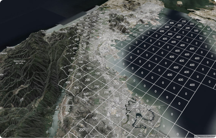
Sparkgeo is a Mapbox preferred System Integrator for Mapbox.com services and is the implementation partner and reseller of the Mapbox Atlas platform. Mapbox provides the building blocks for developers and designers to create beautifully constructed maps and build map-centric applications using leading geospatial SDKs and APIs. If the Mapbox product does not provide an out-of-the-box solution, Sparkgeo works with Mapbox clientele to create custom solutions to match its unique business needs. We do this by applying our knowledge and capabilities within Mapbox platforms and our expertise in the geospatial domain to create a tailored solution for a client’s specific requirements.
Mapbox trusts Sparkgeo to develop elegant solutions for our customers’ most complex geospatial problems.
They have a deep understanding of our tools and an array of experience in geospatial technologies, databases, and software development that helped us get past the finish line on many occasions.

Will White
Founding Team, Mapbox
In 2023, Sparkgeo became an AWS Partner. AWS (Amazon Web Services) provides its customers with on-demand cloud computing platforms and APIs for the scalable storage, distribution and processing of geospatial data. As an AWS partner, Sparkgeo provides AWS clients with the skills, expertise and capacity to deploy scalable geospatial platforms and data pipelines on AWS infrastructure. It is Sparkgeo’s expertise in Extract-Transform-Load (ETL) processes for geospatial data and our long history of deploying solutions on AWS platforms that clients rely on for initial success and long-term scalability.


Since the beginning of 2022, Sparkgeo has been working with the Satellogic team to help them reach their goal of expanding the market for high-quality Earth Observation data. Through this partnership, Sparkgeo has provided ad-hoc software development capabilities and capacity, helping Satellogic accelerate the development of its imagery-serving platform. Sparkgeo also supports the Satellogic team by adding sales support capacity focused on data analytics and has built custom technologies that help Satellogic transform its imagery into analysis-ready data.
From the outset of our work together, Sparkgeo has consistently demonstrated exceptional expertise, dedication, and commitment to quality, delivering results that repeatedly exceed our expectations. Their ability to collaborate effectively with multiple branches of our organization and provide innovative solutions to complex problems has been critical to our success.
We look forward to continuing our partnership with Sparkgeo for years to come.

Emiliano Kargieman
CEO and Founder, Satellogic
A mission-led organization
Founded in 1895, The Wildlife Conservation Society (WCS) safeguards wildlife and wild places. It does so through science, conservation action, and inspiring people to value nature. WCS works to conserve more than two million square miles of wild places around the world. It operates 500 field conservation projects in 65 countries—and has 200 Ph.D. scientists on staff.

Many obstacles; many challenges
The non-profit sector faces compelling and challenging geospatial problems. WCS has an army of dedicated scientific staff. They also have dedicated GIS resources. But, they sometimes need more applied geospatial software development experience. This can be challenging as operational expenses at non-profits are hard to manage.
WCS needs partners who understand their work’s importance, and appreciate that funding is a constant challenge. They need periodic access to software talent. Their project needs are varied. On one project, they quantify how consumption in a location affects wildlife. On another they help re-imagine New York City’s future. On yet another, they required new data collection tools that work in connected and offline environments.
We like solving puzzles
At Sparkgeo, we like solving interesting geospatial puzzles. For WCS, we create tools and environments to share geographic research. We also assist with research that has a geographic component. Our work with WCS is varied and fascinating.
One project involved parsing complex scientific data. We then relay the findings in map form, for general web consumption. We create interactive geographic UIs, including the Horizon Impact Calculator. We helped optimize the NYC Visionmaker. We also built an offline data capture tool called MERMAID
Good partnerships are rewarding
WCS’ mission is part of what makes our relationship with them so rewarding. We like working on meaningful global problems—and appreciate the variety of challenges. Although not-for-profit budgetary constraints can be challenging, we’ve learned how to work within them. We hope to assist with more of this important work.
From the outset of our work together, Sparkgeo has consistently demonstrated exceptional expertise, dedication, and commitment to quality, delivering results that repeatedly exceed our expectations. Their ability to collaborate effectively with multiple branches of our organization and provide innovative solutions to complex problems has been critical to our success.
We look forward to continuing our partnership with Sparkgeo for years to come.

Kim Fisher
Spatial Analyst and Developer at Wildlife Conservation Society