Could location-based technologies have helped prevent the B.C. floods?
British Columbia, December 16, 2021 – It’s no longer a question of if, but when. Following the recent devastation in BC, global geospatial company Sparkgeo, is highlighting the ability of location-based technology to improve the accuracy of risk modelling and planning for future extreme weather events.
In the past five years, British Columbia has experienced a drastic increase in extreme weather events driven by climate change including windstorms, wildfires and flooding. All have caused mass destruction and put an incredible strain on provincial resources and budgets.
The recent record-breaking flooding in southern British Columbia is estimated to have caused $450 million in insured damage, according to preliminary data released by the Insurance Bureau of Canada. The disaster will be the most costly weather event in the province’s history, the industry organization said in a news release, and the overall economic losses are expected to be much higher.
The underlying technology that makes sense of location-based data is called geospatial technology, and it’s available now.
By using commercially available satellite imagery, and other remote sensing satellites, geospatial companies have the ability to harness enormous amounts of geographic data and pair it with historical data and meteorological data to help leaders more accurately analyze and monitor climate events and their potential impacts.
“BC’s current statistical models for predicting weather events are built around these events being rare occurrences, which is no longer the case,” says Will Cadell, Sparkgeo CEO. “With geospatial technology, we have access to the data to create more comprehensive exposure models to better protect our homes, our lands, and our environment when the next weather event occurs.”
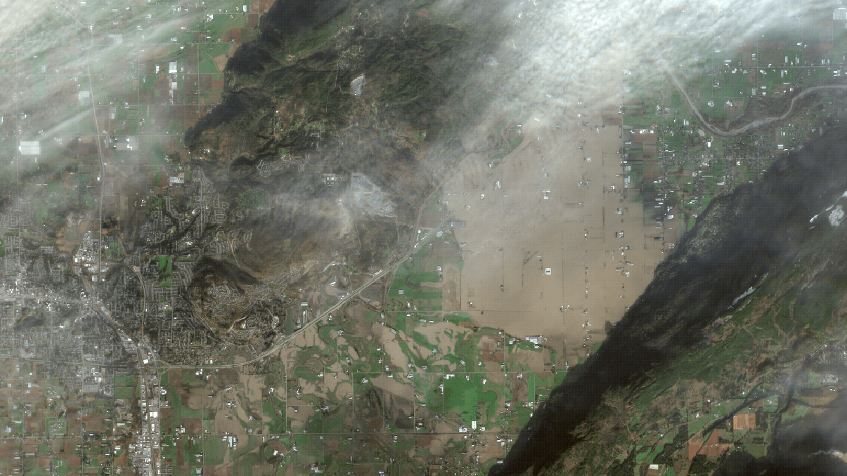
Recently, the team at Sparkgeo compiled satellite imagery and geographic data to release a series of animations on the Sumas floods in Abbotsford, BC. This data provides intelligence about the flow of water around the dam breaks and identifies future hotspots for water pooling – data that when accurately reported on could have significant impacts on risk planning for future flood events in the area.
Geospatial platforms can connect data from multiple climate-related events like linking wildfire damage with increased flood risks. Just like we have a walkability score for homes, we could have a climate exposure scale for every building in BC, or even the planet.
“With many of our team based here in BC, we’re passionate about what is happening locally,” added Will. “While we can’t prevent these extreme weather events, we would love to discuss the opportunities we have at our fingertips with location data, planning and risk planning with local government officials and experts.”
The need for tangible solutions with climate impact technologies is growing across the globe. Sparkgeo partnered with the Wildlife Conservation Society (WCS) and the World Wildlife Fund (WWF) to create MERMAID. This platform aggregates and manages data on coral reef health empowering scientists, communities, and governments in linking science to rapid action in marine conservation efforts.
To learn more about geospatial data and Sparkgeo’s research into the Sumas floods, visit their website at www.sparkgeo.com
About Sparkgeo
At Sparkgeo, we provide geospatial expertise to companies. Our obsessive focus on geospatial technology makes us somewhat unique. In fact, most of our work has been with other technology companies who look to us as leaders in this field, combining our team’s expertise with their in-house team. We’re curious, listen carefully, are platform-agnostic, and afford critical value to our clients.
Contact
Will Cadell, CEO (North America) [email protected]
Dan Ormsby, UK Lead [email protected]
Facts and Requests
We have been in business since 2010. Please write our name as Sparkgeo. Not SparkGeo, Spark geo or Spark Geo. Our North American headquarters are in Prince George, British Columbia, Canada and our European headquarters are located in London, England. All of our team members work remotely so you may not find many people in our offices. In fact, when we’re not working there’s a good chance we’re climbing a mountain, biking down one or swimming in a glacial lake.